Grand Plateau RV Resort, Kanab UT
The road from Las Vegas to Kanab is familiar to us; we were on it last year with our camper and back in 2019 with our hiking friends. The location of Kanab near Zion National Park and Bryce Canyon National Park puts it in a unique position as a tourist destination. It is also close to Grand Staircase-Escalante, Vermillion Cliffs, and the North Rim of the Grand Canyon National Park. Our campground is east of town, tucked in under the beautiful red cliffs.
Last night was my first experience of thunderstorms in the desert. You can see the lighting; the spaces are wide open, and then, a while later, you get the thunderclap. The way the clouds roll over the hills is stunning. I did not expect rain at this time of the year; I know monsoons usually come in July and August. It was beautiful in its way.


We drove towards Zion NP but turned around at Mt. Carmel Junction. That ride takes you to the Mt Carmel Tunnel into Zion Canyon.
The views from the road are amazing. We took some detours to explore, but the 450 dually is not meant for off-roading. There are numerous riding trails here, some with good-sized parking lots and pit toilets. We will properly explore them later this week.
To get our feet wet, or sandy in this case, we did a short hike at Sand Caves, just north of town. A nice walk through the wash is a clear reminder of the rains that come through here. Then, a good scramble with a rope assists you to a ledge that leads you to a series of caves. These were man-made during sand mining operations years ago. It was fun exploring them, and Tom had a great time assisting other hikers as they navigated the scramble.


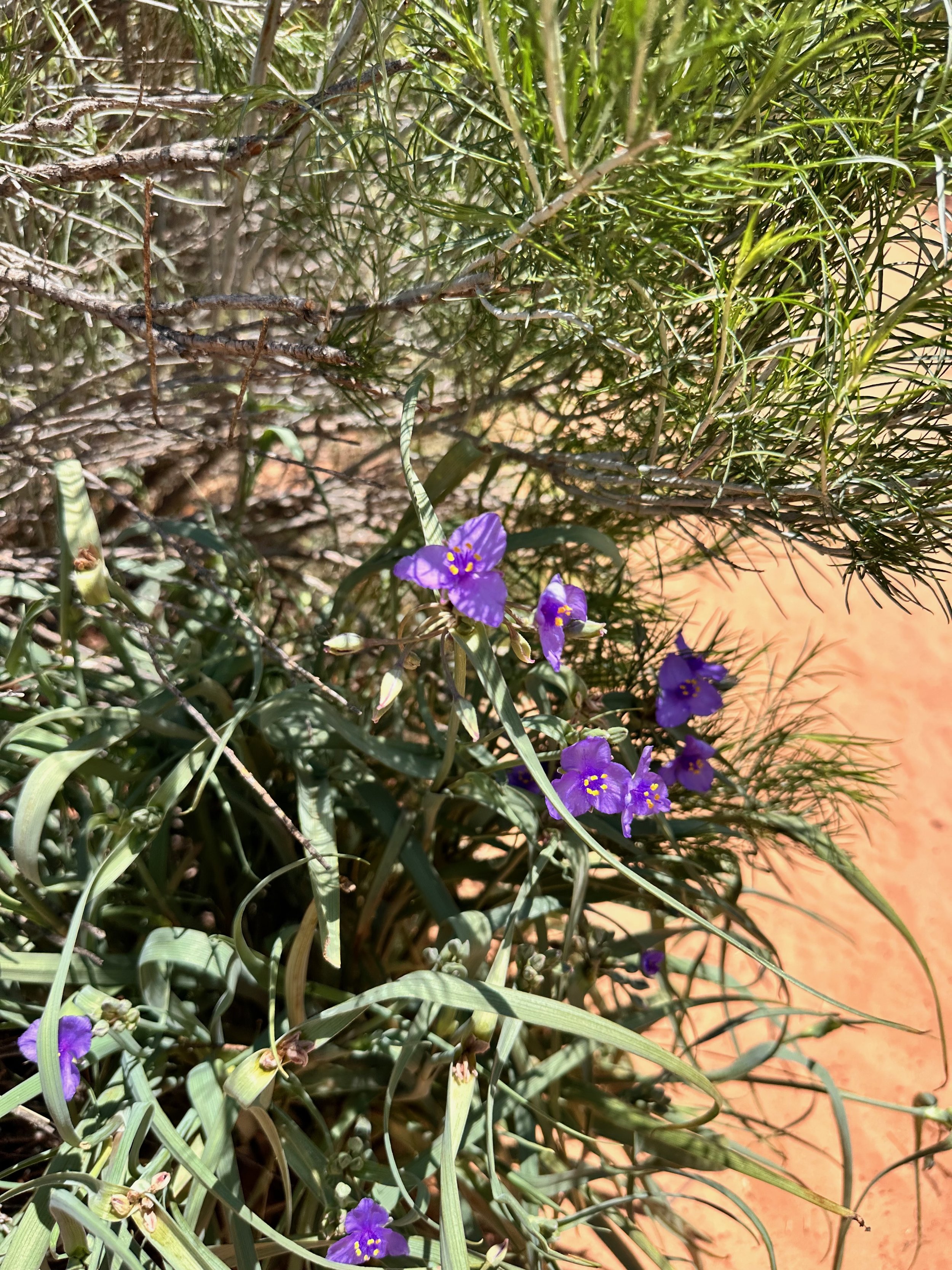
The wildflowers in this area always take me by surprise, as it is technically a desert, receiving less than 10 inches of rain annually. The area around Kanab appears to have an abundance of trees and bushes, with Kanab Creek and the Virgin River providing the water.
I did not ask Tom to drive to Best Friends Animal Shelter and Rescue. It is a few miles north of Sand Caves. I would be tempted to adopt a cat, a dog, or another pet, and that would not be good.
My consolation prize was lunch at Wild Thyme Cafe. A nice, fresh Mediterranean salad for me, and a Wild Thyme salad with chicken for Tom. Good way to end today's adventure


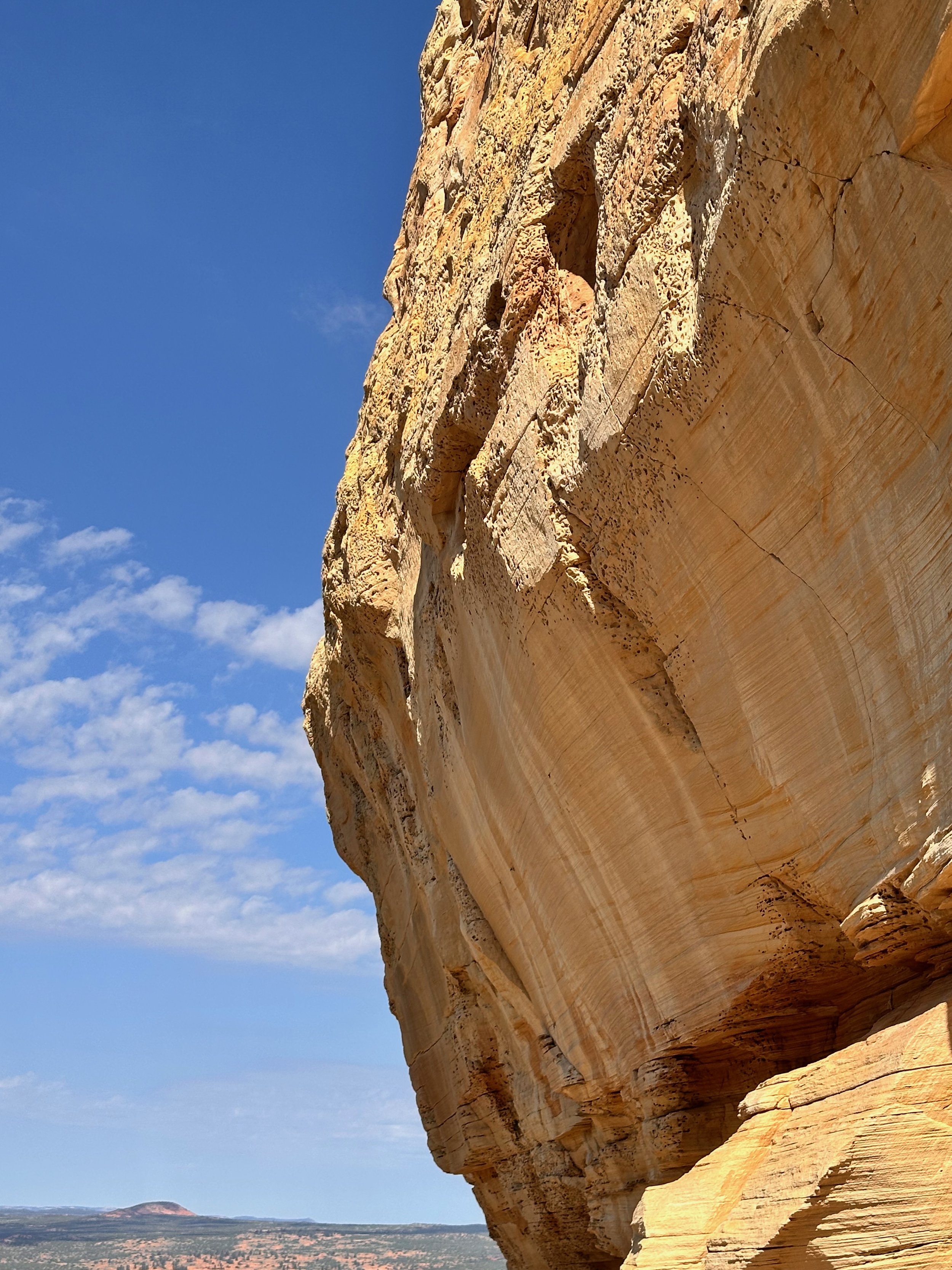
We explored another area east of Kanab and near Page, Arizona, which is part of the Grand Staircase-Escalante National Monument. The Toadstools Trail is a short hike, about one mile long, but it leads to an incredible area filled with unique geological formations, quite different from the Sand Caves. Vegetation is sparse, with a few plants along the wash.
As we began the hike, it was fascinating to observe the changes in terrain. The trail starts in a flat, sandy valley featuring a wash or arroyo, then rises to a section with higher cliffs that includes a natural bridge and a narrow path. Then, you come to an open area with a few toadstools—spike-like features characterized by a rock perched on top of a thinner pedestal. The bottom layer erodes more quickly than the top, and you can see some “caps” in the open area that are just millions of years away from becoming toadstools. The trail ultimately ends at large white cliffs, where the east side offers a couple of intriguing overlooks. Although there is a short and steep climb, the views are worth the effort.
I was surprised by how soft and crumbly the rocks were on this side. The west side features a trail that leads to the rim of the formation, culminating in several toadstools nestled within a large rock alcove. It honestly feels like another planet, with layers of rock in various colors exposed to the elements. You can see the significant impact that water has had in this area, especially since rain can arrive with considerable force. This is just a small corner of the Grand Staircase-Escalante, and I’m again stunned by the geology of this place.


On Friday, we took an ATV excursion with Kanab Tour Co. We opted for the 5-hour tour, which included the Great Chamber, a massive sandstone alcove, and Peekaboo Canyon. We got lucky; no one else opted for this tour, so it was just us and our guide, Heather. Our trip started in town, but we quickly arrived at Hog Canyon, and the fun began.
The trail took us up to the ridge overlooking the town. Interestingly, we identified the neighborhood we drove through earlier. The views were terrific, and the morning air was still cool. Heather described the Grand Staircase, a formation that spans southern Utah and northern Arizona. The sandstone layers of ancient inland sea are exposed at different levels over time, just like cake’s layers. South of Kanab are the Chocolate Cliffs (also in the North Rim of the Grand Canyon), followed by Vermillion Cliffs(Kanab and west of Page AZ along the Colorado), White (like in Zion), Gray (between Zion and Bryce), and Pink Cliffs (Bryce and Cedar Breaks). It is hard to imagine the scale of this - frankly, I’m still learning and putting a mental picture together.
Tom had a blast driving the RAZR. Heather took us on some slickrock formations; it was steep going up and down, and a few times we were pretty close to the edge. It was great fun, and thanks to the rain the day before, the dust was minimal.


Our first stop was the Great Chamber. It is an immense alcove at Cutler Point, northeast of Kanab. It features a large dune in the center, which is spectacular. The hike to it is short, just 1/2 mile; the last couple of hundred feet are steep and sandy. Heather pointed out some animal tracks on our trail; one looked to be the kangaroo rat, a small rodent with a long tail that hops to move along. Once we got closer to the Great Chamber, we noticed holes in the sandstone cliff. Bees make these. They chew on the rock or use water to weaken it. It’s a new species discovered just 40 years ago called Anthophora pueblo. Here’s an interesting article about it.
We found more kangaroo rat prints on top of the dune within the Chamber. From the side of the Chamber, from Cutler Point, you can see far across the hills. It was a magical experience.


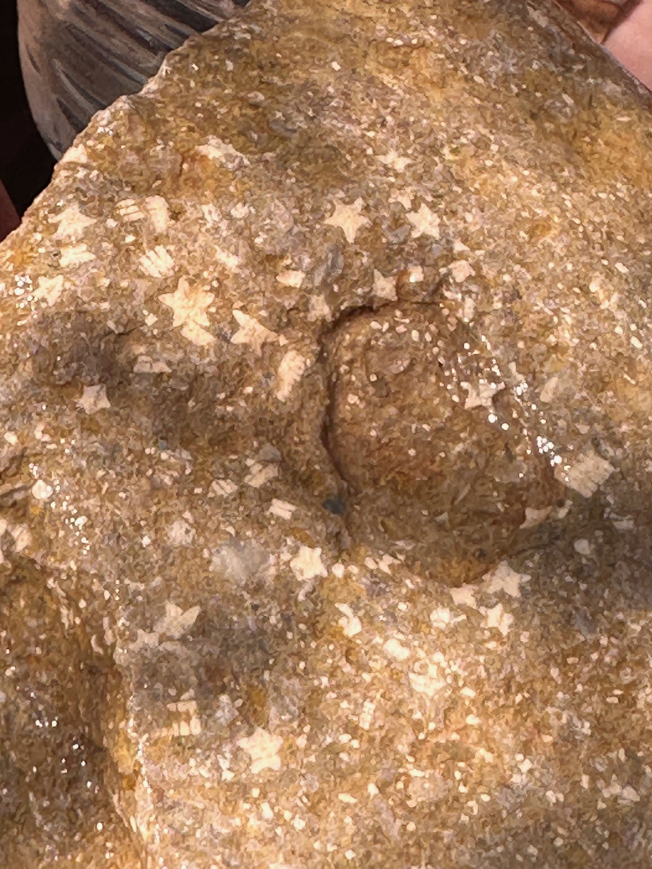
We drove for a few miles to get to our next stop, Peekaboo Canyon . It is a short hike, and the canyon is breathtaking. You could see the different rock layers perfectly matched on both sides of the canyon. There are Moqui steps, made by the ancient Pueblo people, which were used to access food caches on the canyon ledges. There are tree trunks stuck across the canyon, brought there by flash floods. Finally, Heather pointed out fossils in some of the rocks; once you poured water over the rock, you could see that they were the remains of sea lilies. This area is a wonderful place filled with many interesting things.
I enjoyed this adventure very much and still ended up with plenty of “Kanab rouge” on my face!


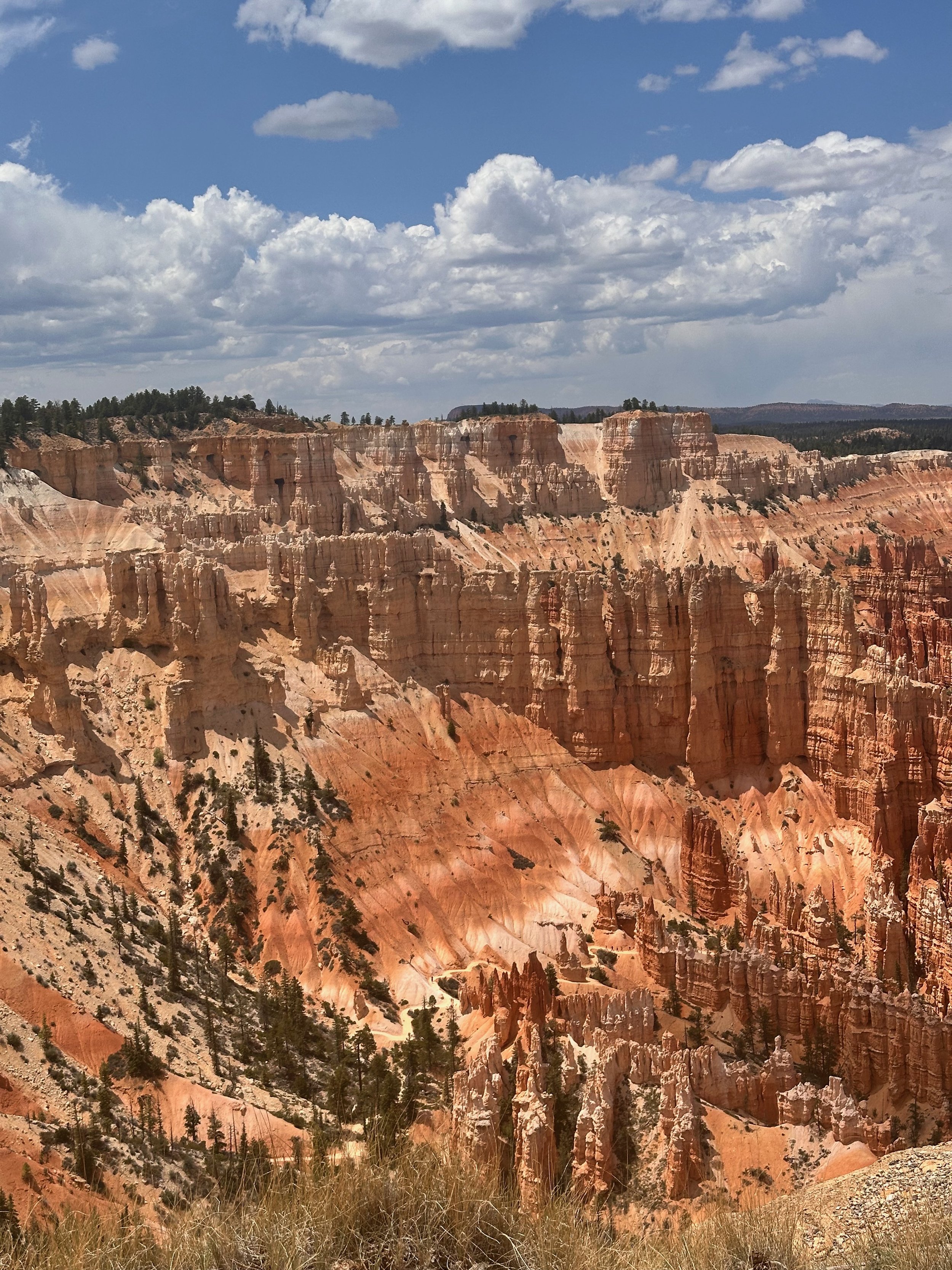
We planned to drive to the North Rim of the Grand Canyon, but that fell through. The park experienced an electrical outage; as a result, the lodge, gift shop, and bathrooms were closed. We decided to drive to Bryce Canyon instead. It is a scenic drive, passing Mt. Carmel Junction, which leads to Zion National Park and Route 143, heading to Cedar Breaks National Monument. We visited both of these parks last year. The landscape changes as you go north; it is green with streams and cattle ranches. I have been to Bryce Canyon twice, and each time, I have the same impression as if I was on another planet. The hoodoos and spires are wonderful and strange. We walked along the Rim trail, taking in the spectacular views and recalling our previous visits and hikes with friends. It all came back - Queen’s Garden, Navajo Loop, Thor’s Hammer. We had such great times. I’ve enjoyed that visit. And I drove the truck there, but I couldn't park that beast for the life of me!
We're off to Page, AZ, tomorrow, saying, "See you later” to Vermillion Cliffs in Kanab!